
FishPass Updates
Updated Oct, 2025
Dear partners and stakeholders:
On behalf of the FishPass team, I am pleased to provide an update from August-September 2025.
NOTE: A time-lapse camera has now been installed to capture FishPass construction progress. Check it out here.
Construction:
- Phase 2 of FishPass construction, which includes encompassing the north side of the river inside a sheet-pile cofferdam and constructing the 400-ft L x 30-ft W fish-sorting channels, is well underway. In mid-August, the contractor completed installation of the steel sheet pile cofferdam. Dewatering of the areas inside the cofferdam, which permits work on the fish-sorting channels to be safely completed in a dry working environment, began. The remaining portions of the original Union Street Dam were demolished and sediment and silt have been excavated from inside the upstream cofferdam to prepare for construction of the fish-sorting channel (Figure 1). Material excavated from within the upstream cofferdam was dewatered onsite and disposed at an approved landfill. Installation of the permanent sheet-pile cutoff wall, which will be located underneath the headworks of the fish-sorting channel is expected to begin by November 2025.
- Prior to full dewatering of the area, staff from the Great Lakes Fishery Commission (GLFC) and Grand Traverse Band of Ottaway and Chippewa Indians (GTB) recovered fish entrained in the cofferdam pools (above and below the historic dam) and relocated an assortment of fish back into the river – below the dam. Fish recovered from the upstream cofferdam pool included rock bask Ambloplites rupestris, round goby Neogobius melanostomus, smallmouth bass Micropterus dolomieu, and yellow perch Perca flavescens while fish recovered from the downstream cofferdam below the old Union Street Dam included brown trout Salmo trutta, rainbow trout Oncorhynchus mykiss, rock bass, smallmouth bass, and yellow perch.
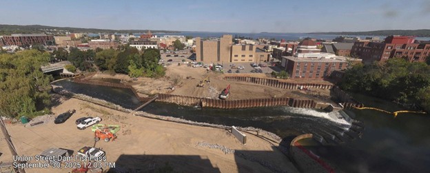
Figure 1. Image from the FishPass time-lapse camera: September 30, 2025 showing flow over the new weirs and into a temporary bypass channel, which permitted the contractor to install the cofferdam around the north bank of the river and begin constructing the fish-sorting channels.
Research:
- Brandon Gerig (University of Wisconsin – Milwaukee), Ross Gay (Northern Michigan University), Reid Swanson (GLFC), and Gord Patterson (Michigan Technological University) recently published a research article in the journal of Integrated Environmental Assessment and Management entitled Potential for contaminant biotransport by migratory fish prior to dam removal and selective fish passage in a Great Lakes tributary. The paper explores the potential for contaminant biotransport in the Boardman/Ottaway River following the planned removal of the Union Street Dam and installation of FishPass. Contaminants (e.g., polychlorinated biphenyls [PCBs], mercury [Hg]) were quantified in carcass and egg samples from migratory species including Chinook and coho salmon, migratory rainbow trout, common white and longnose suckers, lake trout, walleye, and sea lamprey. Chinook salmon exhibited the highest PCB concentrations in both carcasses and eggs, exceeding those of rainbow trout and native suckers. Although suckers had lower individual contaminant burdens, their relatively large run sizes contributed moderately to potential contaminant biotransport compared with rainbow trout, indicating an interaction between abundance and spawner contaminant burden. Stream-resident brook and brown trout in reaches open to migratory fish had higher PCBs and lower Hg concentrations than in closed reaches, likely reflecting dietary exposure to eggs and growth dilution. These results demonstrate that the potential for contaminant biotransport varies widely among migratory species and highlights the need for managers to consider both contaminant burden and run size when making fish passage decisions to balance ecological restoration with contaminant exposure risk. The paper is available at https://doi.org/10.1093/inteam/vjaf087.
- 10 September – GLFC and GTB staff completed the third scheduled "quarterly" index electrofishing survey in the lower Boardman/Ottaway River (below Union St. Dam). These surveys have been conducted annually on the 1st week of May, 3rd week of July, 2nd week of September, and 2nd week of November to understand the seasonal diversity and abundance of the Boardman/Ottaway River fishery in this section of river. During these surveys, GLFC and GTB staff also implant a variety of bio-telemetry tags into captured fish. Bio-telemetry, in the most basic sense, is the remote detection, measurement, and monitoring of animal activity. As such, these tags facilitate ongoing research on fish movement and presence in the river interim to the physical sampling of fish. The use of telemetry tags will further be used to assist the development of FishPass, which will be outfit with numerous telemetry sensors to understand the efficacy of various sorting and selective technology at the site. Results can be found in Table 1; it should be noted that Pacific salmon primarily Chinook Oncorhynchus tshawytscha and coho salmon Oncorhynchus kisutch/ are not enumerated or measured as part of this work. Hundreds of Chinook and coho salmon were identified by staff on this survey but not processed because their numbers are well monitored by Michigan Department of Natural Resources at the Boardman River Salmon Weir. The Boardman/Ottaway River fish community is very much dominated by these introduced salmon in September.
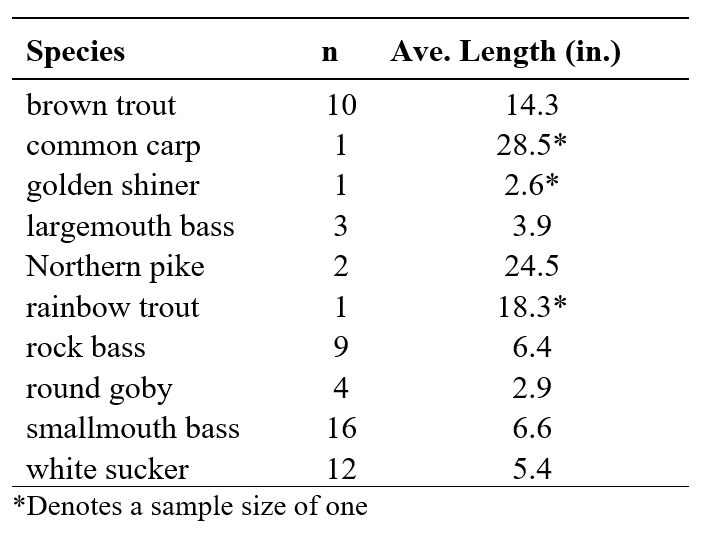
Table 1. Average length and number of fish (n) sampled during electrofishing in the lower Boardman/Ottaway River on 10 September 2025.
- 13 September – The Grand Traverse Band of Ottawa and Chippewa Indians (GTB) Natural Resource Department held a ceremony in Hannah Park to celebrate the second annual release of Nmé or lake sturgeon (Acipenser fluvescens) in the Boardman/Ottaway River. Juvenile Nmé were raised in a GTB stream-side rearing facility further upstream of FishPass in the Boardman/Ottaway River. Stream-side rearing is believed to improve the ability for young Nmé to imprint on the river water and thus increase their probability of return to the Boardman/ Ottaway River. These fish should return in 15-25 years (males 15+, females 20+) and through FishPass, which will provide access to the reconnected upper reaches of the river for spawning allowing them to complete their life cycle. In total, approximately 700 juvenile Nmé will be released in 2025. The GTB plans to continue their stocking program for the next 20 years.
Outreach:
- 8 August – Senior staff visit from the office of Senator Gary Peters (31 participants)
- 18 August – ReShore: Innovation at the intersection of water, mobility and outdoor tech
- 28 August – UnPlugged with 20Fathoms: MI BlueTech Innovation Hub round table
- 12 September – Freshwater Research and Innovation Center ground breaking
- 13 September – Grand Traverse Band Ottawa/Chippewa Indians lake sturgeon release
- 17 September – GLOS leadership visit + tour
- 19 September – Grand Traverse County Commission tour
- 10 September – Rotary Square Citizen Advisory Council meeting
- 20 September – Grand Traverse Band of Ottawa and Chippewa Indians fall festival
- 25 September – Tribal Council FishPass tour
- 25 September – Presentation during leadership Grand Traverse natural resources day
- 29 September – Oceans25
Upcoming:
- 1 October – Blue Tech Challenge Finale – TC-based Wave Lumina Wins
- 14 October – GTCD staff tour
- 17 October – Rotary Club engagement
- 20 October – MSU Innovation Center engagement
- 21 October – Senator Slotkin staff engagement
- 24 October – Alliance for the Great Lakes tour
- 29-30 October – FishPass Advisory Board meeting
- 30 October – Freshwater Summit presentation
- 3 November – Traverse Connect Economic Summit engagement
- 3 November – Traverse City Humanists presentation at the Traverse Area District Library
- 5 November – FishPass public tour
- 6 November – GTRCF MI BlueTech Innovation Hub presentation
- 17 November – FishPass staff will provide an update to the Traverse City Commission.
In the News:
- 6 September – FishPass Enters Final Instream Stage
- 9 September – FishPass Reaches Halfway Point – Spectrum News
- 16 September – How an Automated Fish Sorter Will Help Manage Great Lakes Fisheries
Previous Updates
- Aug-Sept, 2025
- June-Aug, 2025
- Apr-May, 2025
- Feb-Mar, 2025
- November, 2024
- October, 2024
- September, 2024
- August, 2024
- Third Quarter 2024
- Second Quarter 2024
- First Quarter 2024
- Fourth Quarter 2023
- First Quarter 2023
- Fourth Quarter 2022
- Summer 2022
- Spring 2022
- Sept, 2021
- June, 2021
- May, 2021
- Apr, 2021
- Mar, 2021
- Dec, 2020 - Feb, 2021
- Nov, 2020
- Oct- Sept, 2020
- Aug, 2020
- July, 2020
- June, 2020
- May, 2020